NASA/JHUAPL/SWRI


NASA Photos Show Pluto’s Surface Looks Like 'Dragon Scales'
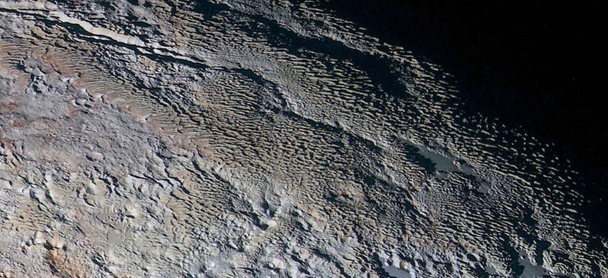
Pluto's mountain ranges are perplexing scientists.
Pluto’s surface is so unusual that even the geologists studying it are at a loss as to how to explain how it was formed. After studying detailed images of the dwarf planet’s surface, William McKinnon, a member of the New Horizons geology, geophysics, and imaging (GGI) team,described it as looking “more like tree bark or dragon scales than geology.”
Scientists got their first detailed look at Pluto’s surface after high-res and enhanced color images from the New Horizon probe arrived on Earth last week (they were taken in July). To take the color images, New Horizons’ camera, the “Ralph/Multispectral Visual Imaging Camera” combined blue, red, and infrared snapshots. Some of the colors were then enhanced to highlight subtleties among the wide range of colors on the surface.
The result was a rich spectrum of colors from deep red to pastel blue. “Many landforms have their own distinct colors, telling a wonderfully complex geological and climatological story that we have only just begun to decode,” said John Spencer, also part of the GGI team.
Here are a few of the images:
 are visible in this enhanced color image of Pluto.")
Details as small as 0.8 miles (1.3km) are visible in this enhanced color image of Pluto.(NASA/JHUAPL/SWRI)
The formation of the mountains on the picture at the top of this article has geologists stumped.
The next image shows a 75-mile (120km) stretch of land. The two red areas are ice mountains, and the plain surrounding it appears pockmarked. This close to the dwarf planet, details up to just 270 meters (0.17 miles) are visible.

Another shot of taken with the “Long Range Reconnaissance Imager” (LORRI) shows what NASA calls “the older shoreline of a shrinking glacial ice lake, and fractured, angular water ice mountains with sheer cliffs.”

(NASA/JHUAPL/SWRI)
Scientists have mapped as much of Pluto as has been photographed on a globe as well. The map on the left shows methane ice, with higher methane levels indicated by the brighter purple, and on the right the methane map juxtaposed with images from the LORRI.

(NASA/JHUAPL/SWRI)