NASA


Hurricane Florence Could Be the Worst Storm to Ever Hit North of Florida
Since records began, only 10 major hurricanes have made landfall around the Carolinas. This one has the potential to blow them all out of the water.
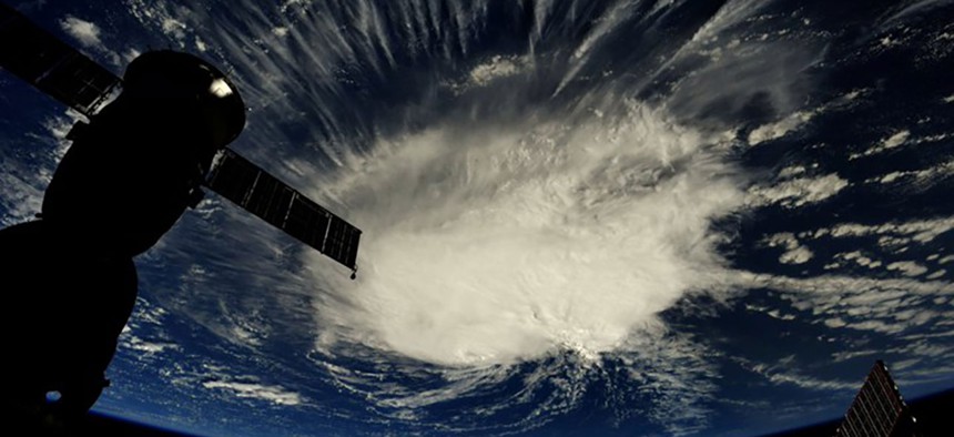
As Hurricane Florence continues its charge toward the southeastern coast of the United States, it now almost certainly will make landfall in North or South Carolina on Thursday. As of 5 p.m. Monday, Florence’s maximum sustained winds had approached 140 miles an hour. The most recent update from the National Hurricane Center said that Florence is expected to strengthen even further, and to retain its status as an “extremely dangerous major hurricane” through Thursday.
If Florence strikes North Carolina at its current classification, Category 4, it would be only the third to do so in recorded history, and the first to do so this early in the Atlantic hurricane season, which runs from the beginning of June to the end of November. It would be the 11th major hurricane to make landfall along the southeastern Atlantic coast, excluding Florida.
Experts weren’t ready to rule out the possibility that Florence could even make landfall as a Category 5 hurricane, a feat never achieved by any recorded storm in the region. Dennis Feltgen, a spokesperson for the National Hurricane Center in Miami, says that reaching Category 5 is “certainly a possibility.” If Florence doesn’t undergo a phenomenon known as an eyewall replacement cycle, which would weaken the storm, it has a chance of reaching the 157-mph boundary line and making history, Feltgen says.
According to Chip Konrad, the director of the National Oceanic and Atmospheric Administration’s Southeast Regional Climate Center and an assistant professor of geography at the University of North Carolina, Florence’s historic winds are a “huge threat” to the region, especially in areas that lie farther inland, where trees and infrastructure are less accustomed to violent gusts.
In terms of lives lost, though, the biggest danger from Florence is more likely to come from flooding than high winds, Konrad said. Although Florence is clipping along at a steady 13 miles per hour through the Atlantic, it’s forecast to hit the brakes once it moves farther inland. That’s thanks to high-pressure air bands to the north and east of the storm that will prevent it from taking the usual hurricane track off the eastern seaboard. Konrad called the atmospheric setup “unusual” and “extreme.” While Florence is parked, it could unload up to 32 inches of rain onto parts of North Carolina and Virginia, which usually only see around 40 to 50 inches in a given year.
This halt-and-downpour scenario is reminiscent of what Houston faced last summer, and a pattern that will only get more likely as the world warms. During Hurricane Harvey, urban sprawl and an abundance of impermeable ground cover made it difficult for the torrential downpour, once dumped, to exit the city. In the Southeast, according to Konrad, steep hillsides and already waterlogged soil will similarly fail to absorb much of the rain Florence will bring.
But the Southeast’s more rugged terrain is likely to produce much different consequences than Houston suffered. “Flash floods are the real danger here,” Konrad told me, as opposed to pooling. All the excess water that doesn’t find its way into the ground will be sent quickly into valleys and ravines. That will likely mean sudden, dramatic flooding downstream, along with landslides.
If Florence makes it to the Appalachian Mountains, Konrad said, things will likely get even worse: The topography will force the storm’s clouds upward, resulting in an effect called orographic lift that will wring even more precipitation from the storm. It’s the same effect that makes the western flanks of the Rocky Mountains so wet, and dumps feet upon feet of snow along the Great Lakes’ eastern shores.
According to Konrad, Florence “has the potential to be the most destructive hurricane we’ve had in modern history for this region.” Feltgen, the National Hurricane Center spokesperson, said juxtaposing Florence with past storms would be a “fatal mistake,” because it could lead those in its path to underestimate the danger. But if the worst comes to pass, Florence may become the region’s standard of comparison for years to come.