


USDA Forest Service Maps the 'Wildland-Urban Interface,' or Areas Most Vulnerable to Wildfire
The agency has plotted where human development comes dangerously close to nature.
In the U.S., the steadiest population growth isn’t happening in urban centers. It’s in suburbs, exurbs, and rural areas. And as we make more and more homes along the very fringes of metropolitan areas, the more we come into contact with natural habitats.
And the consequences might not be obvious. Putting aside conservation concerns, higher numbers in the “wildland/urban interface” (or the “WUI,” as the U.S.D.A Forest Service calls it) means higher numbers of homes vulnerable to wildfire.
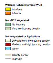
As of 2010, 99 million people, or about one-third of all people in the United States, lived in the WUI. The WUI is is formally defined as any area with at least one structure per 40 acres that’s either next to (what’s called “WUI Interface”) or sprinkled within (“WUI intermix”) a certain minimum expanse of naturally vegetated land. (Urban homes adjacent to a park, for example, wouldn’t included.)
A new map by the forest service shows us where the WUI lies. The agency charts the extent of WUI in the contiguous U.S. every decade, using Census housing data and the National Land Cover Dataset (that’s why this year’s map is for 2010.)
Here’s the map. A scaled-up image of its legend is also below.
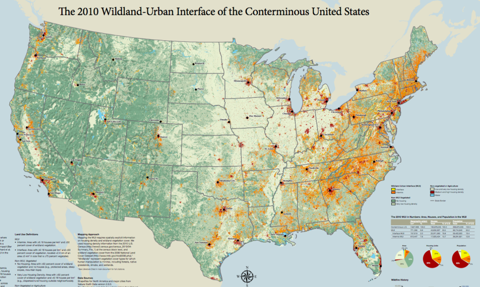
An accompanying report explains that the WUI has grown since the last map was made. Setting aside questions about forest fragmentation, habitat loss, and land conservation—all mighty concerns in their own right—the map is a reminder of how the risk of wildfire is spreading beyond the forest to human settlements.
And this affects people all over the country. Dense development and a lack of much open land means Northeastern states have the highest proportion of WUI land relative to their overall size. In the Southeast, development is springing up in forested areas historically managed by prescribed fire. In much of the West, drought is increasing the potential for wildfire near dried-out places in the WUI.
This summer’s explosive blazes in California illustrate how devastating it can be to have population growth so close to the natural world.
Lake County, California, where September’s ”Valley” wildfire burned about76,067 acres and destroyed about 2000 homes, is home to 63,983 residents, about a third of whom live in rural areas.
“[It] didn't have this kind of population 50 to 70 years ago, which is no less true in Southern California,” Char Miller, a professor of environmental analysis at Pomona College, told the Los Angeles Times. “These fires [are] not only big and fast-moving; the fact that they're overrunning human settlement is new.”
NEXT STORY: Jeb Bush Unveils Energy Plan