Mojave Trails National Monument was designated Friday. BLM


Obama Creates Three New National Monuments in California
Often it seems that modern presidents can’t do anything — except wage war. Here’s a heartening exception.
Being president involves a lot of stress, woe, and impossible-decision making. That’s why all of them, Barack Obama included, look a generation or two older when leaving office than they did when coming in. (For more on the theory of why being president is hard, check “ Obama, Explained .”)
Here’s the part of the job I have always imagined would be the most unadulterated fun. No, not pardoning one of the poor Thanksgiving turkeys, leaving the other to its doom. Rather it’s exercising a president’s on-his-own power, under the Antiquities Act of 1906, to proclaim new National Monuments and thus preserve and protect the nation’s heritage.
Theodore Roosevelt put this power to immediate effect by creating the Devil’s Tower National Monument, now additional famous via Close Encounters of the Third Kind , in 1906. During our travels in Ajo , Arizona (and in my current article ), we described the importance of the Organ Pipe Cactus National Monument , created by Franklin Roosevelt in 1937.
As of yesterday, the total of these protected sites was some 117 . Today the total is 120, thanks to President Obama’s designation of three desert sites in Southern California: Mojave Trails, Castle Mountain, and Sand to Snow. The contours of the monuments may look a little strange, as shown below, but that is largely because they follow natural mountain and valley contours, and are amid other protected lands.
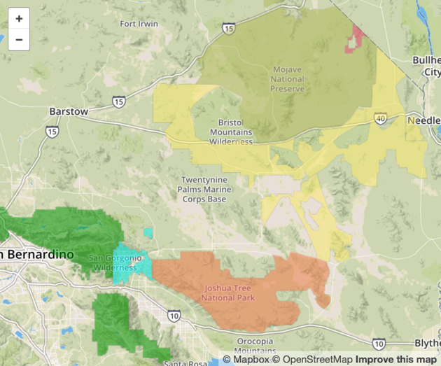
The new areas, in inland Southern California: the green area on the lower left, which mainly covers mountains, is the existing San Bernardino National Forest; and the salmon-colored area in lower center, mainly desert, is the existing Joshua Tree National Park. The light-blue / cyan area between them is the new Sand to Snow National Monument. The olive-green circular area higher up is the existing Mojave National Preserve. The mustard-colored gerrymandered-looking area beneath it is the new Mojave Trails National Monument. The tiny pink area at the top is the new Castle Mountain National Monument. This is an OpenStreetMap map, as produced by the Desert Sun .
***
This announcement coincided with the president’s travel to Palm Springs, immediately adjoining one of these areas, for an ASEAN meeting at the Sunnylands center. And it followed a long push by California’s Senator Dianne Feinstein to protect the three areas. The Sand to Snow monument, more mountain than desert, has a surprisingly rich diversity of plants and animals. The flatter desert areas faced encroachment from development in general, and in particular from rapid recent installation of solar and wind-power farms . Yes, even clean energy involves its tradeoffs.
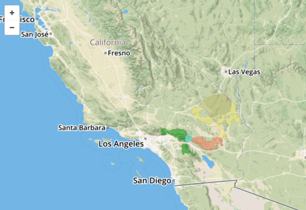
It’s been a contentious struggle, as this LA Times story lays out. Another source of opposition was the off-road motorist community, which objected to the limits that National Monuments place on driving over the terrain. For instance, one of them told the Riverside Press-Enterprise “All those little dead-end spurs that people venture down in order to disperse and find solitude, those are the ones that will all be closed.” But the case for preservation won out. Feinstein’s letter to Obama last year making the case for the protection is in a PDF here ; her reaction to today’s announcement is here . And here is a clearer idea of where the new areas fit in California, with the same color scheme as above.
***
Why do I mention this? First, because in an era of national-level political impasse, to me it is encouraging that a leader, regardless of party, can take such a step in the broadest national interest. Nothing is forever, but preserving wild land is as close to a permanent effect as a president can ever have.
Also, these join the American Futures cavalcade because the Sand to Snow National Monument adjoins cities we have reported on: Redlands , San Bernardino , and Riverside . And while this matters only to me, these happens to be the areas where I went on camping expeditions as a Boy Scout, and that my father explored with his friends on their trail-riding trips. (National Monuments have varying rules about camping, but most permit it in some form. I don’t know about horses.)
Here is an interactive map from the Wildlands Conservancy , with Esri “story map” software, telling about Sand to Snow.
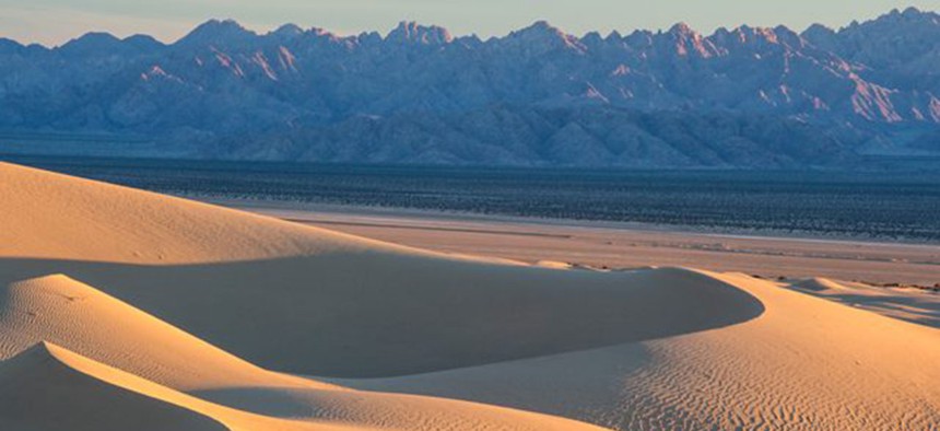
Several times last year, while traveling from Ajo to San Bernardino for reporting, we passed right by Mount San Gorgonio, around whose flanks the Sand to Snow monument is located. This is how it looked from the south a year ago this week, during the heart of California’s long drought. If I’ve worked out the maps right, much of what you see is now protected by today’s order.
The pace of land protection often picks up in a president’s final year. This is a good start for 2016, President Obama! Don’t slack off now.